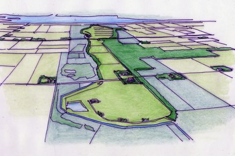
Vienna
Rotes Wien (Red Vienna)
If one speaks about housing, one often refers to the model in Vienna. But what is that Viennese model? We will take a walk through history of housing in this city.
Almost thirty years ago, together with our good friend and building historian Jan van der Hoeve, we went in search of the bastides in France. We had come across these towns through a publication by Robbert Jongepier: ‘Bastides of Gascony, or: medieval new towns built between ca. 1250–1350 in southwest France.’ He self-published this work with a small print run 1977 followed by a reprint in 1982. All the illustrations in the publication were hand drawn. During our quest we discovered more information, a series of booklets: ‘Bastides du sud-ouest’ by the Société Académique d’Architecture, published between 1991 and 1997.
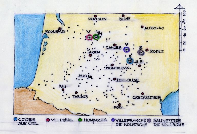
The bastides turned out not only to be in the Duchy of Gascony, but also in the old counties of Toulouse, Périgord, and Auvergne. The area can be roughly outlined by the rectangle with Bordeaux in the northwest corner and Carcassonne in the southeast corner. The bastides captured us so much that around 2000 we returned to discover even more. And after 25 years, it seemed a good idea to refresh our memories.
What makes the bastides so remarkable is that they are medievally founded towns. Not places that grew slowly, but mostly planned settlements at crossroads, by a river, or on a ridge. The word ‘bastide’ for these new towns comes from Gascony. It is estimated that about 320 such towns were founded by the French or English kings together with landowners. The systematic founding of these towns began in the 13th century. Count Raymond VII of Toulouse had to assure King Louis the Saint (1226–1270) that he would dismantle 30 fortified towns and establish only towns without defensive works. From documents it can be deduced that his son-in-law, Alphonse of Poitiers, founded about 35 towns. Under English rule, from the reign of Henry II starting in 1154, a series of towns had already been established. To the east and south of Bordeaux, along the Dordogne and Garonne rivers, more than 70 bastides were founded between 1263 and 1297. Under two French kings, Philip the Bold (1270–1285) and Philip the Fair (1285–1314), 40 bastides were founded.
The bastides were usually founded without their future inhabitants. The foundation was marked with a wooden post or something similar, and recruiters would go around to find new settlers.
Jongepier points out that the bastides mark the shift from the changing political and rival powers of lords and kings toward the increasing importance of trade and industry and the rise of the bourgeoisie. The functions of the bastides were as centres of colonisation in sparsely populated areas and as strongholds in disputed regions. From the bastides, the land was cultivated, and roads were laid out to open the territory. The inhabitants—whom Jongepier calls colonists—were ‘free’ people, not serfs or bondsmen. Thus, they were granted the right to hold markets and receive plots of land and building materials to construct their houses, with the obligation to do so within a certain period.
It was not difficult to attract people by offering greater personal freedom, the inviolability of the home, and the absence of arbitrary taxation by the lord. They appointed their own city government, which was a major change from the hereditary succession of members of city councils that had been customary until then. Free elections were held, and the council was composed of three to eight consuls who could not be of noble birth. At the head of the council stood a bayle, appointed by the king, who also acted as chief judge.
The bastides interest us from an urban planning perspective. The majority of all bastides were laid out in a characteristic grid pattern. What is puzzling is how such a city plan came about. Jongepier does not provide an answer to this either. Was this the beginning of systematic urban planning after the Romans? Historical documents do show a variety of parties that played a role, such as bailiffs, notaries, judges, mayors, and governors. These were dignitaries chosen to divide up the land and set the prices.
It is also not the case that there was an underlying single urban planning model; only the regular pattern—the grid structure—is characteristic. The model was adapted to each geographical situation, for instance, to differences in elevation. That uniformity, however, had a reason. They were all new foundations in empty areas, and often multiple foundations commissioned by a single king or lord. A framework was sought for the public buildings: the church, the town hall, and the market square. A regular and geometric form made the division of the land into equal plots much easier. In this way, it expressed the social equality of the inhabitants. Ramparts, fortifications, and towers usually came later, when circumstances required them. The bastides stand as witnesses to modernisation, somewhat surprisingly, within the Middle Ages.
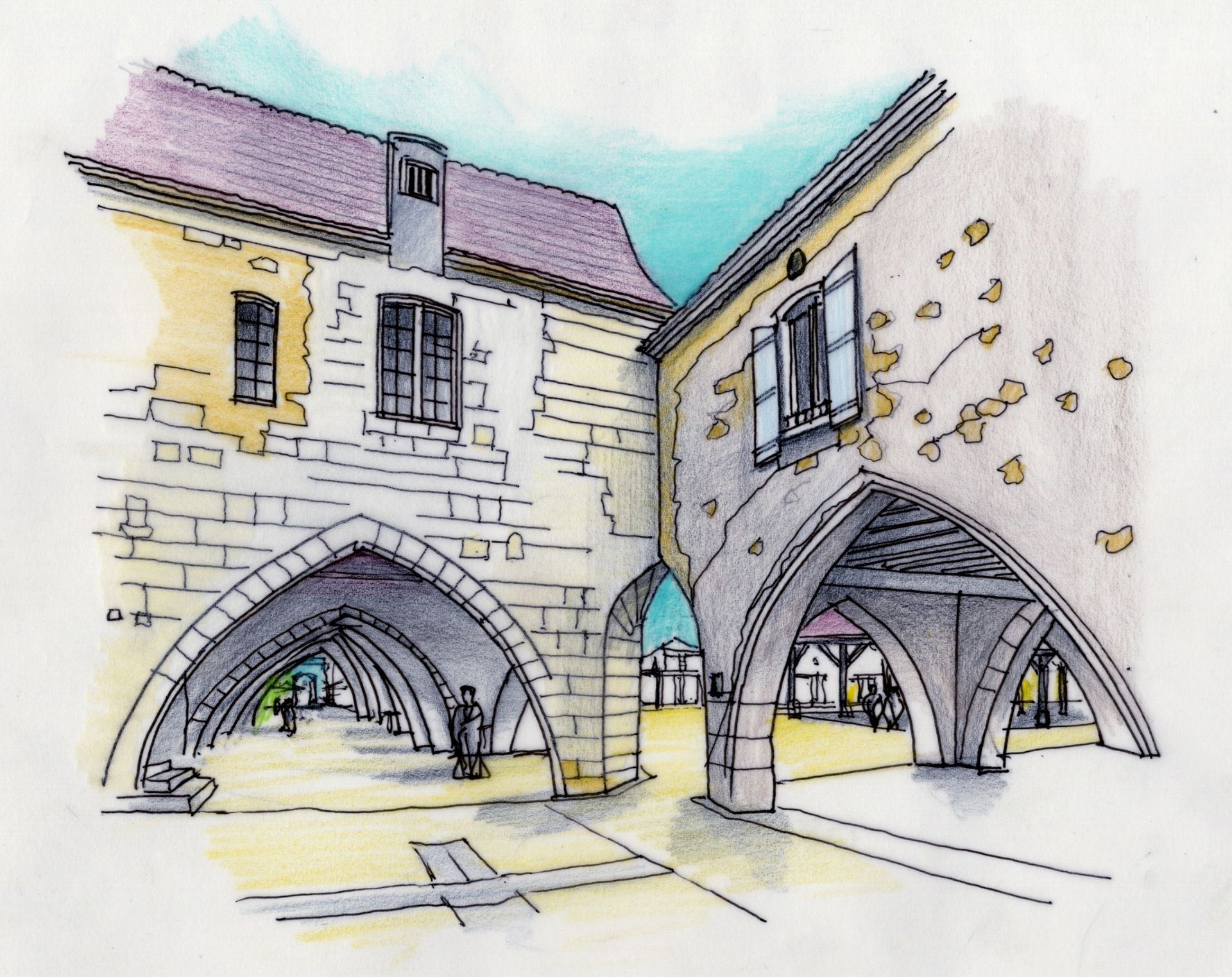
Jongepier carried out an extensive study of the typology of the bastides. He distinguishes them according to their location, outer shape, grid pattern, and the position of the church. Other features of a bastide are the arcades around the central square. The arcade is a continuous space beneath the buildings on the side of the square. These arcades are deep, sometimes as much as 6m to 8m. They provided shelter from the weather (sun and rain) and space for trade and social gatherings. One is not inclined to walk onto the square itself but to follow the natural line under the arcades. There is ample space for cafés and restaurants to set up terraces within the arcade.
The arcades are formed by round or Gothic stone arches or straight wooden structures. The central square is always connected via the main structure of the grid pattern. Remarkably, the street opens directly onto the arcade—so the street flows seamlessly into the covered space.
We would like to take you along to five of these bastides that stood out to us or touched us in one way or another.
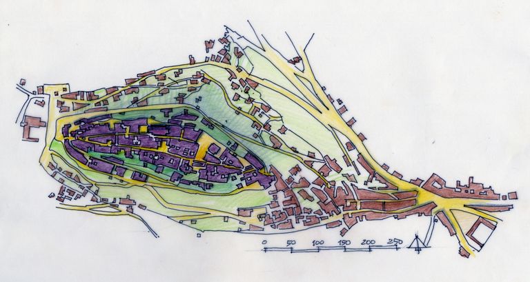
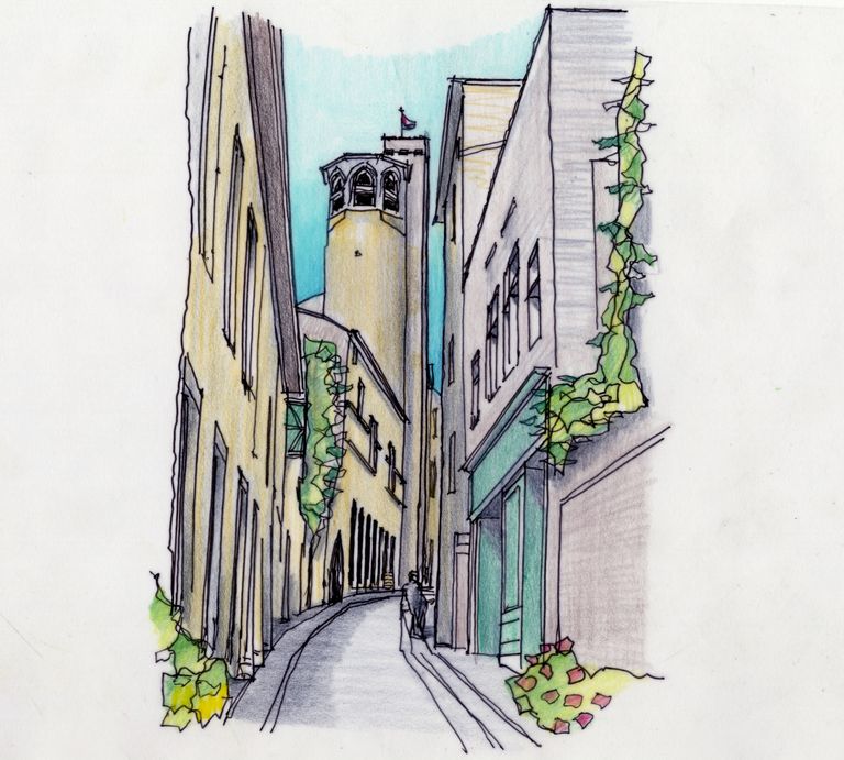
Perhaps not the most recognisable, but certainly the most touristic of the bastides: Cordes-sur-Ciel, near Albi. As the name suggests (Cordes in the sky), is a town perched on a rather steep hill. Because of the hill—called a puech—the grid pattern is less noticeable. The town was founded in 1222 by King Raymond VII. Until 1229, it had a double wall around it. As the population grew, construction also spread onto the slopes of the hill, leading to a third and later a fourth ring of walls. From the 19th and 20th centuries, houses were also built at the foot of the hill. From the Place de la Bouteillerie, you can now take a little tourist train upwards, which stops at the Porte des Omeaux.
From this gate, you can choose between two parallel streets: the Rue Saint-Michel, which takes you to the church of the same name, and the Grand Rue Haute, lined with a large number of impressive Gothic houses. Unfortunately, the church was closed when we were there. The Gothic houses were built almost simultaneously around 1270. They are three and sometimes four storeys high, with characteristically shaped Gothic windows. The façades are decorated, often with animal motifs, which explains the names of the houses, such as Grand Veneur (great hunter) and Grand Falconnier (great falconer). The tourist office is housed on the ground floor of one of these Gothic buildings. Through the entrance and an inner passage, you arrive at the courtyard, where you can see the balustrades of the upper floors.
Both streets lead to a square with a large 14th century market hall. Due to the lack of ornamentation, you might think it is younger. Twenty-four tall octagonal columns support a high roof. Under the roof stand a cross and a well. From both main streets, you then arrive at a second square: Place de la Bride. Here, at an altitude of 290m, you have a fine view of the surroundings. The Grand Rue Haute, descending, leads to the Porte du Vainqueur and the Tour de Barbacasse, dating from the 13th century. From the Grand Rue Bas, the road drops steeply downhill. Along the way, you pass the Chapel of Saint Crucifix from the 16th–17th century and the Porte de l’Horloge built in two periods, the 14th and 16th centuries.
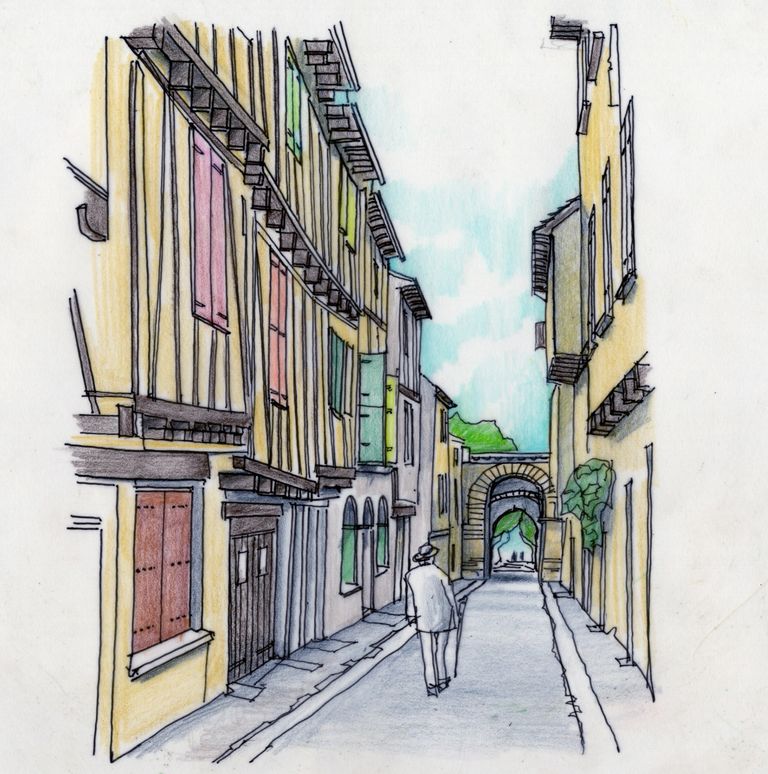
Parallel to this main structure are narrow backstreets, running lower along the hill. The Rue Obscure - what’s in a name? - is partly inaccessible today, but via the Rue de Mitons you can continue the route and reach the gate. This way, you gain a complete picture of the town: the mansions of the notables and the homes of the other townspeople.
The main feature of a bastide that can be found in Cordes-sur-Ciel is the parallel street structure enclosing a square. A market hall on the square is common in bastides and expresses the importance of trade for these towns. The grid structure is less developed here due to the hillside location. Furthermore, all the buildings are made of the same stone, which gives the town a uniform appearance, even though the houses themselves differ from one another.
Villeréal lies on the River Dropt in Lot-et-Garonne. It is a that was never fully built up. In 1265, Alphonse of Poitiers signed a contract with Gaston de Gontaud and the monastery of Aurillac to found a town in the forest of Montlabour. The town was located precisely on the dividing line between the territories under French and English rule to defend the French territory.
The city plan has a geometric layout with two main axes running north–south and two axes running east–west. At the intersections of these axes lies the central market square. The shape of the town plan is almost a semicircle on the west side and diamond-shaped on the east side. The town’s edges were formed by branches of the river. Judging by the position of the church, which does not fit into the geometric pattern, the town was built on a site where people were already living. There is a square in front of the church, but it feels more like a leftover space.
The church of Notre-Dame is very different from the churches in the surrounding area. It was designed in the southern Gothic style and from the start had a dual function: a house of worship and a refuge in case of hostilities. The latter also explains why it was built as a kind of mini fort. The building was surrounded by water and accessible only via a drawbridge. Two square towers flank the entrance and are connected by a bridge. The left tower contains a spiral staircase with loopholes, while the right tower once had a prison space above it. In 1794, the accompanying fortress was demolished. In 1881, the church underwent a major restoration: new vaults and a gallery were added, and the interior was altered. From the market square you can see the church’s tall towers.
Not all the buildings on the central square have arcades. On the south and west sides, the arcades disappeared after a monastery was demolished to make room for the town hall. On the other sides, you find rounded stone arches and arcades resting partly on massive stone columns and partly on wooden pillars. Above the arcades, several half-timbered houses are visible.
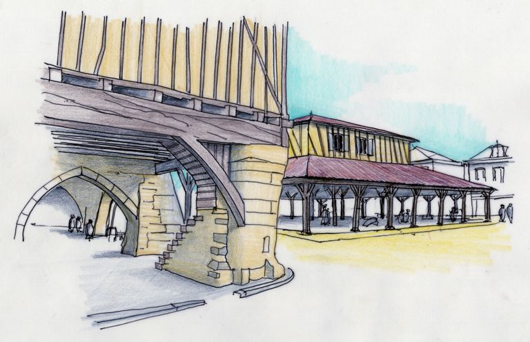
The most striking feature on the square is the wooden market hall, la Halle. The hall has a square floor plan. The first hall was built around 1305. At the beginning of the 16th century, it was rebuilt using materials from the 14th and 15th centuries. It is an oak timber-frame construction in the shape of a pyramid without a top. On top of the hall, a chamber was built, the maison de jurade. This was the meeting place for the local magistrates. A small tower once stood on the roof. Inside the market hall, you can find the staircase leading up to this chamber. The market hall is still used today for the traditional Saturday morning market and for other town activities.
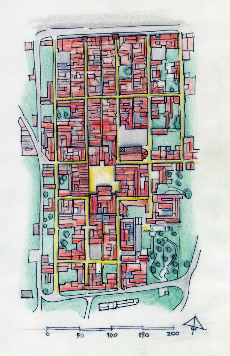
Monpazier may well be called the ideal bastide. It possesses all the characteristics of a bastide: an orthogonal structure, a rectangular plan, great regularity in the street pattern, an almost centrally located square with a small market hall, and still three of its original six city gates.
It was a founded by the English King Edward in cooperation with the landowner, the Baron of Biron. The bastide owes its form to the boundaries of his estate. It covers 53 hectares. The English king wanted to found the town to defend the northern border of his territory in Guyenne, the plateaus between the rivers Dropt and Dordogne. In the archives of the Périgord, a letter about the founding of the town can still be found. It reads as follows:
“His most serene Prince Edward, King of England … wished to have a city built in the region of the Périgord … and in the year 1284, on the 7th of January, toward this end the Lord and Baron de Broin, bowing to the will and desire of the English Majesty, granted the site for the building of a city, and it was named Monpazier.”
In a contract, the city’s jurisdiction, the rights to bake and slaughter, the market, land taxes, and gardens were equally divided. The citizens had to swear an oath of loyalty to both the king and the baron, each of whom held the right to appoint a bailiff. The privileges of the inhabitants were laid down in a charter and later in letters patent. For example: exemption from certain taxes, the right to sell their ‘goods and property’ at will, to marry off their children or send them to monasteries. They could not be imprisoned except in cases of murder. Three annual fairs and a weekly market were permitted. Naturally, there were various payments that had to be remitted to the king.
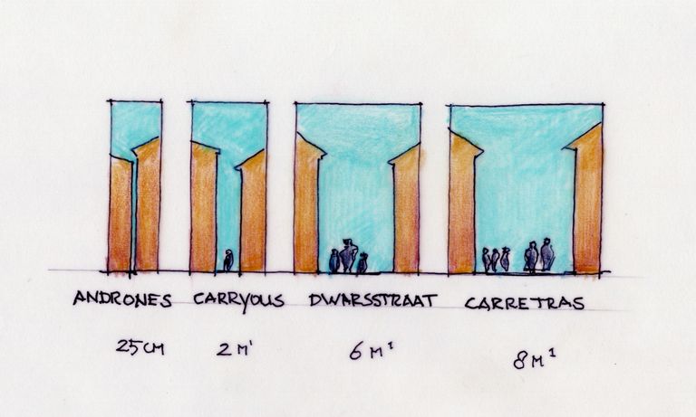
In Monpazier’s nearly perfect grid structure, the hierarchy of streets is very clear. The main streets (carreteras) are between 7.5m and 8m wide. Three streets run north–south and two east–west. These streets enclose both the market square and the church. The cross streets outside the centre are narrower, about 6m wide. The back alleys (carreyous) are about 2m wide. Between the buildings themselves, one often sees narrow spaces of about 25cm (andrones), which served as rain gutters and also contained toilets—though that may be too grand a word for a plank with a hole in it (permitted until 1834). The plots defined by this street layout are almost all the same size: 7.5 by 23m. In all honesty, every street in Monpazier is worth strolling through. Because the town stands higher than its surroundings, you have direct views of the green countryside through the gates.

On the market square stands a medieval open market hall for weighing and temporarily storing goods. It is a timber structure with a stone counter beneath it. On the square you also find a large cross and a well. The arcades take various forms: round arches, Gothic shapes, and straight openings where the wooden beams are still visible. At the corners, the buildings meet on the upper floor in what is called a cornière, making the whole square feel enclosed. Fittingly, the square is named Place des Cornières. The main streets lead directly into these arcades. Through one of the cornières, you catch a glimpse of a side door of the church.
One building stands out in particular: the Grange aux Dîmes, located roughly opposite the church. With three full storeys, it is taller than most buildings in town. It served as a warehouse where taxes on all goods were also assessed.
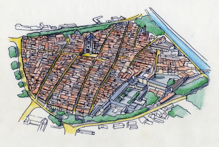
The of Villefranche-sur-Rouergue was founded in 1252 to relieve the nearby bourg (castle) and provide space for new inhabitants. It was an excellent location, where the rivers Aveyron and Alzou meet and old trade routes crossed, and where the village of La Peyrade once stood. For the foundation, a site was chosen on the opposite bank of the Aveyron, on a gentle slope less prone to flooding. The land belonged to Alphonse of Poitiers, brother of Louis the Saint. In the layout of this bastide, there is a clear distinction between the centre, subdivided into equal-sized blocks, and the surrounding area (the bari) intended for gardens and vineyards. The land outside the 14th century walls was designated for agriculture. Even today, you can recognise the sparsely built-up areas of the town within its diamond-shaped outline.
In truth, Villefranche-de-Rouergue is not entirely a bastide like the other settlements. The city’s administration was formed by notables, and people had less freedom to settle here. The elite decided who would leave the bourg—it was, in a sense, a feudal and economic colonisation. The city was subdivided into four gaches or districts, each governed by a consul. The consuls were under royal supervision but enjoyed wide powers in fiscal and organisational matters. The colonists had fewer freedoms and no obligation to build quickly. As a result, construction progressed slowly after the foundation. Only the houses of the wealthy had been built before 1258. But prosperity soon increased, leading to a densely built-up town.
The street plan consists of five main streets running east–west, two main streets running north–south, and numerous narrow side streets, resulting in narrow, deep plots. The market square and the church are in the northern part of the city, not in the centre as in other bastides. The square is a fine example of what characterises many bastides: all its sides are lined with arcades, forming a continuous façade with several cornières. The buildings are three storeys high with steep roofs, befitting the urban character of this place. The true peculiarity of Villefranche-de-Rouergue is that the church, the Collégiale Notre-Dame, stands on the market square, with its tower directly on the square and the arcades. Indeed, the arcade even passes beneath the church! The intention was to outshine the cathedral of Rodez, but due to lack of funds the tower reached only 58m, while the cathedral’s tower stood 87m tall. Because of the church’s positioning, the market hall was later— in the 19th century—built at the edge of the town, behind the church.
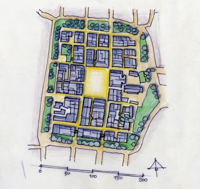
The smallest bastide we visited, but one that truly touched us, is Sauveterre-de-Rouergue. It measures only 150m by 200m. Guillaume of Vienne and Mâcon founded in 1281 on behalf of Philip the Bold. The reason for its foundation was again different: to protect people from bands of highway robbers.
There are four main streets dividing the town into eight blocks and a relatively large market square of 50m by 60m. The blocks are further subdivided by small streets, each block in a different way. Sometimes the narrow streets run across the entire block, but sometimes they end in a dead end. You can wander here without getting lost, because the main structure is so clear. History records that more than 1,500 people once lived here and that within the walls there were various institutions such as a school and a hospital. It is hard to imagine now.
What makes this bastide so special, is that even in such a small bastide, you can still experience the fortifications so vividly. Large sections of the walls remain, surrounded by a green embankment and part of the moat. On the south side, two of the four gates have been preserved: Porte Saint-Christophe and Porte Saint-Vital. These gates lead onto the two main streets, which here are only about 4m wide. In the southeast corner of the town, amid greenery, you find another tower: the Tour de la Mérette. As the defensive function disappeared over time, doors and windows were added into the façades on the south side of the bastide, opening directly onto the green surroundings.
The square, aptly named Place des Arcades, has been arranged so that no cars can park there anymore. This allows a clear view of the buildings around the square, all with rounded arcade arches and two full storeys above them. Next to one of the arcades, there is also a staircase leading down to a cellar beneath, once used as storage. On the ground floor, people cooked or had shops; the upper floors were living quarters, and the attics were used to store grain. In the square itself stand a crucifix and a well. From the square and an eastern street, you reach the entrance to the church. It stands together with its cemetery (now a rose garden) on the edge of the town. The church dates from 1313, as a stone above the entrance indicates. It was recently restored, with the wooden choir stalls (15th century) and pulpit (19th century) particularly noteworthy.
South of the bastide, you can still find a séchoir à châtaignes. This is also called a secador: a drying house for chestnuts. The surrounding area was rich in chestnut forests. Until the early 20th century, these were important for the rural population. Chestnuts provided a welcome supplement during poor harvests and were used to make bread and porridge. On the ground floor, a flameless fire was lit and maintained for three to six weeks. The chestnuts were laid on the openwork floor above it. This is the first time we encountered such a building.
We are struck again by a feeling we often get when exploring a series: it leaves you wanting more. Each bastide that is new to you feels somewhat familiar because of its shared features. This drives you to look for what makes each bastide different, and to understand why. If there truly are 320 bastides, then there must be many more fascinating ones well worth visiting.
2025