Borders in motion
Crossing borders is fun and exciting. Since European integration and the Schengen Agreement, national borders have become less noticeable than they used to be. Although that has been changing again in recent years, especially in Germany. A good place to experience this is the city of Görlitz and, more than 50 km farther north, the Fürst Pückler Park in Bad Muskau.
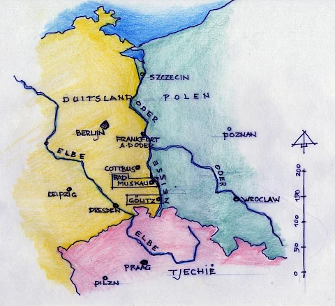
The easternmost city in Germany is Görlitz; it lies farther east than Dresden. The city borders Poland. In fact, on the opposite side of the River Neisse - which forms the border - lies what was once the eastern part of the city in Poland. It is now called Zgorzelec. As in many border regions, numerous wars were fought here, with different countries repeatedly claiming control. Such a history leaves its marks, both in the urban landscape and 50 km north of the city in Bad Muskau, also situated on the Neisse.
‘Turbulent’ is perhaps the shortest possible summary of the history of Görlitz. As early as the Middle Ages, it was an important city located on the Via Regia (the Royal Road). This trade route stretched from Santiago de Compostela in Spain to Kyiv and Moscow. In Leipzig, it crossed the Via Imperii (Imperial Road). The city belonged to the Six-City League of Upper Lusatia. In addition to Görlitz, this trading alliance included the towns of Löbau, Bautzen, Zittau, Kamenz, and what later became Luban (German: Lauban), and it existed from 1346 to 1815. It formed part of what was known as the Holy Roman Empire, a loose federation of states, city-states, and ecclesiastical territories nominally ruled by an emperor elected by prince-electors. From 1438 onward, the emperor was almost always a Habsburg residing at the imperial court in Vienna. Under Emperor Charles V, the empire flourished greatly; during this period, the Netherlands was also part of the empire. Around 1500, the walled city of Görlitz had 8,000 inhabitants.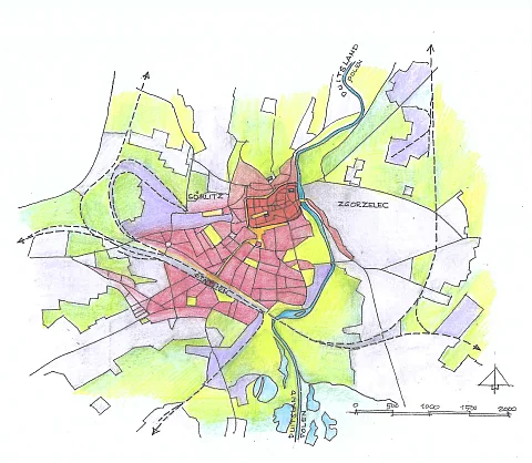
A big fire marked the city’s history. On the night of 12 to 13 June 1525, a fire broke out in a bakery near the Neisse. One third of all buildings were destroyed, and many people were killed or injured. The period that followed could be described as the city’s first reconstruction. This took place under the direction of the city master builder Wendel Roskopf (1485–1549). He introduced Renaissance architecture to the city, traces of which can still be found everywhere today. More on that later.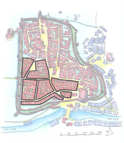
The urban development started with the construction of railway connections to Dresden, Berlin, and Breslau (today Wrocław in Poland) in 1847. Industries - especially textiles, mechanical engineering, and later optical manufacturing - established themselves in the city and attracted new residents. By 1850, the population had already doubled; it doubled again by 1870 and once more by 1910, reaching 86,000 inhabitants. This period of growth is clearly visible in the residential districts developed during the Gründerzeit (second half of the 19th century). The city developed elegant residential neighbourhoods with parks and gardens. As a result it became a true pensionopolis: very popular among retired Prussian civil servants. A favourable tax system, good railway connections, and the surrounding natural environment attracted hundreds of wealthy families. This, in turn, led to the construction of trade schools, a theatre, shops, and cafés.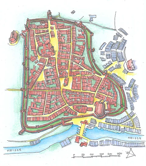
After the collapse of Nazi Germany, the German territories east of the Oder and Neisse rivers were assigned to Poland. The eastern district of the city became Polish and was renamed Zgorzelec. Zgorzelec and Görlitz thus became two separate towns in two neighbouring countries. In 1950, the GDR (to which Görlitz now belonged) and the People’s Republic of Poland signed the ‘Treaty of Görlitz,’ in which they mutually recognized and guaranteed the new border.
Shortly after the war, the city’s population rose to just over 100,000 due to the influx of refugees from Silesia. From that point onward, however, the population began to decline; from 78,000 in 1988 to 56,000 today. Zgorzelec, by contrast, experienced population growth. Before the war, this part of the city had 9,000 inhabitants. After 1945, many residents moved westward. They were replaced by Polish settlers, and the town now has 28,000 inhabitants.
After the fall of the Berlin Wall in 1989, three border crossings were opened in the city: the city bridge in the south, the old town bridge in the centre (for pedestrians and cyclists), and a railway crossing, as well as the Autostrada 4 motorway crossing slightly farther south. Border posts painted in the national colours mark these crossings. In 1990, the Federal Republic of Germany signed a border treaty with Poland, a prerequisite for reunification with the GDR. During my first visit to Görlitz in 2013, the border could only be noticed by the border markers. By 2025, the situation had changed. Since 16 September 2024, Germany has reintroduced border controls with Poland, despite the 1985 Schengen Agreement. Soldiers now stand guard on both sides of the river.
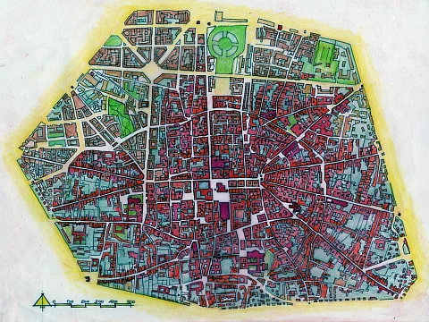
History has left its marks on Görlitz in a very different way than in many other cities. Parts of the medieval city walls are still visible, along with three city gates: the Nikolaiturm, the Reichenbacher Turm, and the Frauenturm. Behind the Reichenbacher Turm — which can be visited and offers an excellent overview of the city — a section of the old fortifications has survived in the form of a round bastion. Known as the Kaisertrutz, it now houses the city museum, which provides valuable insight into the history of Görlitz.
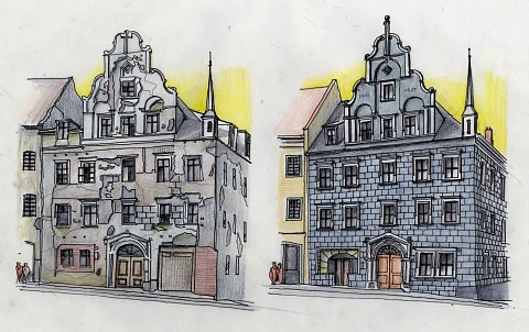
In Görlitz, one hardly encounters any major urban interventions within the historic urban fabric. Urban expansion during the late nineteenth century mainly took place along Berliner Strasse toward the railway station. Unlike many other German cities, Görlitz suffered no wartime destruction from bombings or fires. During the GDR period, the authorities tended to attach little value to the historic buildings and often sought to demolish them, but fortunately heritage conservation agencies were frequently able to prevent this. It is thanks to this attitude that, together with its partner city Wiesbaden, the Görlitzer Fortbildungszentrum für Handwerk und Denkmalpflege was established in 1991. It is also thanks to this period of stagnation that many historic buildings have survived.
During our most recent trip to Görlitz, we managed to acquire a wonderful book: Auferstehung eines Denkmals Görlitz, Fotografien von Jörg Schöner (2016). This photographer, born in Dresden in 1944, took photographs of Görlitz during the 1980s. In 1979, the Saxon State Conservator suggested that he travel to Görlitz for his graduation project and photograph the old town before it collapsed or was demolished. He was given two years for the assignment. At the time, architecture and buildings played almost no significant role in East German photography; the emphasis was on reportage and social themes. In the archives, Schöner discovered many photographs by Robert Scholz (1843–1926): 5,000 glass negatives documenting everyday life in Görlitz around 1900. The State Conservator had judged the situation correctly. The city was in a deplorable state. In the book, Görlitz is described as “a mixture of neglect and morbid charm.” Schöner took more than 2,500 black-and-white photographs of the city. He exhibited them in 1992 at the museum in Wiesbaden. In 2005, he returned to the city and took colour photographs at exactly the same locations, often showing restored buildings. In the 2016 book, the old and new photographs are placed side by side. Together, they provide a clear impression of the enormous efforts made to restore the city.
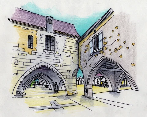
‘City of the Renaissance’, that was what stayed with me after our first visit. The reason this struck me so strongly probably lies in the fact that the Renaissance left far fewer traces in the Netherlands. The great flourishing of the Dutch Republic occurred mainly during the Golden Age (1588–1672), just after the Renaissance period. What makes Görlitz so fascinating is that this history can be found in many ordinary buildings throughout the city, not only in the town hall, churches, or other monumental structures. A good example is the Untermarkt, next to the town hall. Around the square stand large so-called Hallenhäuser. This type of building was constructed particularly in Görlitz around 1500. The houses were built above arcades that sometimes rise more than one storey high. This building type was ideally suited to merchants, as it allowed them to display their goods under cover. A particularly remarkable building is the Ratsapotheke, completed in 1552. It was designed by the city architect for Sebastiano Hoffmanns. On the first and second floors, the building features a Renaissance-style corner oriel window turned diagonally toward the street corner. Two original sundials can still be seen on the façade. On the first floor of today’s Ratscafé, an original interior from the construction period has been preserved. The building to the left of the Ratsapotheke is another beautiful example of a Renaissance house with four storeys, the upper two of which served as storage space.
One of the city’s most remarkable streets is Peterstrasse, where many buildings still feature Renaissance portals. The most striking building — also featured in Schöner’s book — stands on the corner with Nikolaistrasse. It was probably built in 1544 by the city master builder. During renovation work in 1895, the characteristic Renaissance façade painting was added: grey imitation stone blocks with white joints. This building also has a Renaissance portal. Another building with a remarkable Renaissance façade painting is the Waidhaus and warehouse from the late fifteenth century (Waid was the German word for indigo), located next to St. Peter and Paul’s Church.
The oldest part of the city lies between two very different churches. The aforementioned St. Peter and Paul Church stands on the city’s highest point beside the River Neisse; after the Lutheran Reformation, it became a Protestant church. The foundation stone of the current church was laid in 1423. It is a late-Gothic five-aisled hall church, meaning that all parts of the interior are of equal height. The building is 72 metres long and 39 metres wide. The ceiling consists of a net vault with ribs painted in light grey. After a major fire in 1691, the church was adapted in the Baroque style. The two striking neo-Gothic towers date from 1891. One of the church’s highlights is the so-called Sun Organ (Sonneorgel). The organ was built in 1697 by Eugenio Casparini together with his son Adam Horatio. The organ case, designed by Johann Conrad Büchau, is decorated with seventeen circular suns. The quality of the original organ, however, was poor. In 1997, a new organ was installed within the historic casing, and this was expanded between 2004 and 2006.
The church on the western side of the city is the Church of the Holy Trinity. This is the oldest church in Görlitz and originally belonged to the Franciscan monastery. Its foundation stone was laid in 1234. Two Romanesque columns with triumphal arches still testify to this early period. In 1371, the church was expanded with a Gothic choir and a tower. Around 1420–1450, the Barbara Chapel, with its net vault, was connected to the monastery. The chapel contains numerous artworks, including the oldest surviving gravestone from 1381 and a wooden sculpture of the contemplative Christ dating from around 1500. More than a century later, in 1564, the monastery closed, and from 1548 onward the church served the Evangelical community. Particularly remarkable is the fact that part of the monastery cloister was incorporated into the southern side of the church. As a result, the vaults and wall paintings from 1425–1435 have survived. The narrow hall church consequently acquired an unusual reorientation perpendicular to the nave. Since 1715, the church has been known as the Church of the Holy Trinity (Dreifaltigkeitskirche).
Görlitz is one of the few cities in Germany where pre-war synagogues can still be found — in fact, there are two. The old synagogue from 1853 still stands in Langenstrasse. In 1870, the local Jewish community established a fund for the construction of a new synagogue. The number of Jews in the city had grown from 111 in 1849 to 694 in 1890. Merchant, entrepreneur, and city councillor Emmanuel Alexander Katz purchased a plot of land near the park in 1907 and donated it to the Jewish community. An architectural competition was organized for the design of the new synagogue, which was won by William Lossow (1842–1914) and his son-in-law Max Hans Kühne (1874–1942) from Dresden. They were later known for their design of Leipzig’s main railway station (1909-1915).
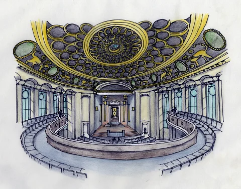
The new synagogue was built in 1909-1911. From the outside, the design appears modern and restrained. The architects collaborated with well-known artists, although this only becomes apparent once inside. There, the building is richly decorated with Art Nouveau elements and Moorish-Byzantine motifs. It was constructed using building techniques that were highly modern for its time. The large circular central hall, for example, is crowned by a reinforced concrete dome. Around this central hall, which accommodated 280 men, all other rooms were arranged, including the entrance hall, cloakrooms, toilets, weekday prayer room, and caretaker’s residence. Above was the women’s gallery with seating for 220 women.
From 1933 onward, the Jews were expelled from the city, and after 1945 there was no longer a Jewish community in Görlitz. As mentioned earlier, Görlitz suffered very little war damage. During Kristallnacht on 9 November 1938, the synagogue was set on fire, but the fire brigade succeeded in saving the building. In 1963, the synagogue became property of the municipality, which converted it into a theatre. However, the building gradually fell into disrepair. In 1972, the city considered demolishing it, but this was prevented through the intervention of the heritage authorities. Restoration of the dome became urgently necessary and began in 1990. Numerous proposals for new uses were considered, including a theatre, swimming pool, library, gymnasium, and concert hall.
During the 1980s, awareness of the city’s Jewish history began to grow, and in 1988 Kristallnacht was officially commemorated — notably during the GDR period. From that moment onward, a group of residents campaigned actively for the preservation of the synagogue. Restoration work was carried out during the 1990s. In 2004, a foundation was established to oversee the use of the building, focusing on the history of Judaism, tolerance and civic courage, music, literature, art, and the traditions and perspectives of Central Europe. The synagogue can now be visited through guided tours, and there we experienced one of the finest guided tours we have ever attended.
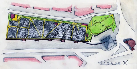
The memory of Görlitz’s Jewish history can also be found in the Jewish cemetery in the southwestern part of the city. It is now owned by the municipality. The cemetery is accessible during the day (except on Saturdays, the Sabbath) and is well worth visiting. It contains 569 grave monuments set within a park-like landscape of approximately 4,700 square metres - quite unusual for a Jewish cemetery. Since 2015, a modern memorial has commemorated the 323 victims of the Biesnitzer Grund concentration camp and crematorium. It consists of a corten steel structure with seven vertical pillars and seven beams fitted with glass panels - seven being an important number in Jewish tradition. Names are engraved on 148 of the glass panels, while blank panels symbolize the unidentified victims. The beams between the glass panels provide space where visitors may place small stones. The old gravestones are all oriented toward the east. Many of the monuments have weathered considerably, as Jewish graves may not be cleared away. The grave monuments of the family of the previously mentioned Emmanuel Alexander Katz are works of art in themselves. The graves of other prominent Jewish citizens, including Louis Friedländer, can also be found here.
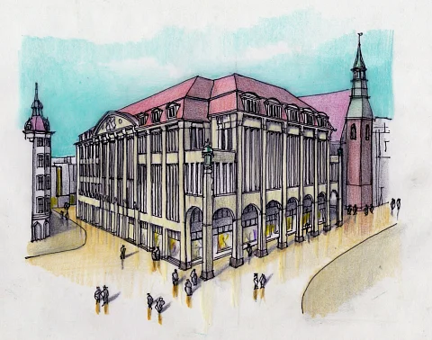
Louis Friedländer was the man who founded the first true department store in Görlitz on Marienplatz in 1898: Zum Strauss. This building was later demolished in 1912–1913 by the businessmen Lindemann and Ploschitzki and replaced by one of the most beautiful department stores in Germany. The Kaufhaus Wertheim in Berlin served as its model. The design was created by Carl Schmanns (1880–1960) from Potsdam. The exterior is a fine example of Art Nouveau, with a richly detailed sandstone façade. What is truly remarkable, however, is the interior of the store, centred around a spacious atrium crowned by a spectacular glass dome. Daylight draws attention to the staircases with their richly decorated columns and Jugendstil ornamentation. The grandeur of the interior is enhanced by the large and elaborate chandeliers, although these are replicas dating from 1993. After initially being taken over by a small local company, the department store was acquired in 1929 by Rudolph Karstadt AG. Following the Second World War, the store became part of the state-controlled retail sector in the GDR, during which several restoration projects were undertaken to preserve its architectural heritage.
Despite the challenges posed by changing economic conditions, the building remained a cherished landmark. In 2012–2013, it gained renewed fame as a filming location for ‘The Grand Budapest Hotel’. Görlitz is sometimes nicknamed ‘Görliwood’ because its historic cityscape lends itself so well to film productions. Several scenes from the 2009 film ‘Inglourious Basterds’ were also shot there. In August 2009, the Karstadt department store in Görlitz went bankrupt. The building subsequently became the property of a local entrepreneur, Prof. h.c. (RCH) Dr. Med. Winfried Stöcker. His dream is to restore the department store to its former glory using contemporary shop-in-shop concepts, and plans have already been drawn up for this purpose. It now remains to be seen whether and when this vision can be realized.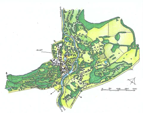
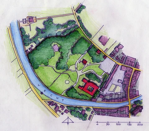
We now make an excursion to the northernmost point of the Görlitz district, where borders can also be experienced: the Fürst Pückler Park, which since 1945 has been divided between the German side near Bad Muskau and the Polish side near Łęknica. This too has served as a location for numerous films, though mainly because of its rural landscape character. The town of Muskau has held town privileges since 1452. Situated along the River Neisse and surrounded by forests, it became a centre for timber construction and related industries such as paper production. During the first half of the nineteenth century, Count Hermann von Pückler-Muskau (1785–1871) created one of Europe’s largest landscape parks here. It covered 830 hectares, much of which consisted of managed woodland. From 1822 onward, the count was permitted to style himself Fürst (Prince) of Muskau.
In 1822, mineral springs believed to possess healing properties were discovered south of the town. This prompted the prince to open the Hermannsbad spa in 1823. Bad Muskau thus became a spa resort known for its mineral waters, the fresh air of the Muskau Heath, and the scenic river landscape. By creating a vast landscape park, Pückler established a transitional zone between the town and the surrounding countryside, where industrial development would later take place. Indeed, nineteenth-century industrialization brought new industries such as glass and ceramics production and the exploitation of lignite mines.
Pückler was an enthusiastic traveller. Between 1806 and 1810, he journeyed through southern Germany, Austria, Switzerland, Italy, and France. After travelling through England in 1814–1815, he became one of the foremost admirers of the English landscape garden tradition.
He became deeply impressed by the English landscape style. This provided the inspiration for the landscape park in Bad Muskau. The head gardener, Jacob Heinrich Rehder, oversaw the creation and maintenance of the park from 1790 until his death in 1852. An area of 257 hectares was redesigned as a romantic landscape park. A new branch of the River Neisse was excavated, complete with ponds, waterfalls, islands, and bridges. Trees, some already forty years old, were transplanted in order to create carefully composed sightlines, supported by extensive planting schemes. The existing changes in elevation, the vegetation, the riverbanks, the ponds, and the bridges were all arranged in such a way that the existing palaces - the Old and the New Castle - were shown to their greatest advantage. The old palace was demolished down to part of the original fortress and later rebuilt, while the orangery and the former stables were restored.
At several locations in the park, quotations by Fürst Pückler are displayed on signs. One of them reads:
“Der Garten
ist eine ausgedehntere Wohnung.
Alles biete hier Schmuck
sorgfältigste Haltung, und so viel
Pracht dar als die Mittel erlauben.”
“The garden
is an extension of the home.
Everything here should offer beauty,
the utmost care, and as much
splendour as the means permit.”
Fürst Pückler, 1834
Between 1826 and 1829, Pückler travelled once more to England, and later, between 1834 and 1840, he shifted his focus toward North Africa and the Far East. After completing the park at Bad Muskau, he went on to create two additional landscape parks: one at Babelsberg near Berlin (1842–1857) and another at Branitz (1845–1870). The Pückler family had purchased the village of Branitz near Cottbus in 1696, and the family castle was built there between 1770 and 1771. In 1845, due to financial difficulties, the prince sold the park and castles at Bad Muskau. He returned to Branitz and began work on a new landscape park there. He died in the castle and was buried in a pyramid situated in the lake of the park.
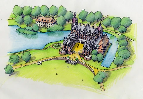
The new owners of the Fürst Pückler Park sold it one year later to Prince Frederik of the Netherlands (1797-1881), of the House of Orange-Nassau, who expanded the spa resort. The Dutch prince left his own mark on the estate by rebuilding the castle in Neo-Renaissance style. However, this appearance can no longer be seen in its original form, because on 30 April 1945 the castle collapsed after being set on fire. As the park became part of the GDR after the war, the property was confiscated. In 1955, the building was placed under heritage protection.
Reconstruction of the castle began in 1993. The south wing was completed in 2008, after which an exhibition about Fürst Pückler — as he was usually called — was opened there. In 2012, the west wing was completed, containing a wedding hall, exhibition spaces, and a tower. The tower can be climbed and offers splendid views over the building and the park. In 2013, reconstruction was completed with the restoration of the grand ceremonial hall. Today, the castle is striking for its red stucco façades, white horizontal bands, and ornamental detailing. The Old Castle — the two-storey building near the park entrance — also fell victim to wartime fire. Between 1965 and 1968 it was rebuilt. It is now used by the local authorities, while the park foundation houses its archives there.
After the war, the park was divided between different countries: the GDR and Poland. Maintenance of the German section was taken over by heritage authorities in 1953, although upkeep had already declined under the last private owners, and the park had fallen into neglect. The Polish section came under the control of the state forestry enterprise. The park now covers a total area of 545 hectares. In 1988, representatives of both countries began discussions that eventually led, in 1989, to a joint agreement for the reconstruction and restoration of the landscape park. This cooperation resulted in the establishment of a joint foundation in 1993. The culmination of this collaboration came in 2004, when the park was designated a UNESCO World Heritage Site.
The park is wonderful for walking and cycling and is freely accessible during the daytime. The paths cross the River Neisse at several points — and thus also cross the national border. Nothing within the park itself reveals which country you are in, although the Polish section contains more variation in elevation and more woodland. Just as in Görlitz, the border is indicated by coloured border posts about two metres high. And, just as in the city, soldiers now stand guard over these borders. One could almost say they are bored out of their minds. A portable toilet stands beside them — probably just as well, otherwise you might unexpectedly encounter a soldier relieving himself in the bushes. Unfortunately, this international park is no longer without borders.
2026